02-06-2026
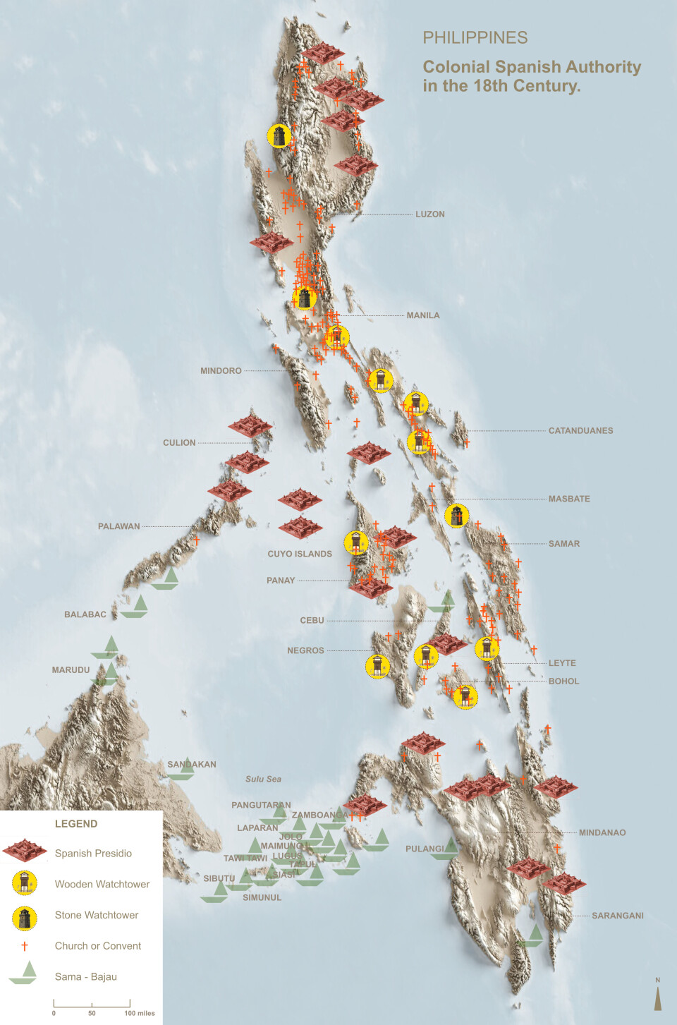
Reconstructed map of probable Sama-Bajau presence in the Sulu Archipelago during the eighteenth-century. Based on Warren (1981), Flannery (2024) and anchorage symbols from Murillo Velarde (1734). Created by Nomiki Karellaki & Despoina Palogiannidi, 2026.
This blog is a summary of internship report and M.A research of Ms. Nomiki Karellaki, supervised by Grace Leksana (Utrecht University) and Wengki Ariando (KITLV).
The Sama-Bajau under Spanish Colonial Rule
For over three centuries, Spanish colonial administrators tried to map, tax and convert every population in the Philippine archipelago. However, the Sama-Bajau, sea nomads present in the Sulu Archipelago since at least the ninth century, left almost no trace in the documents Spanish colonial administrators produced as if they had never existed at all. They supplied the pearls, sea turtle carapace and marine products that sustained the entire regional economy. Why then does Spanish colonial documentation from the eighteenth century treat them as though they were invisible?
This was the central question driving a recent MA thesis completed in connection with the sea nomad research at the Royal Netherlands Institute of Southeast Asian and Caribbean Studies (KITLV) under the project of Tracing evolutionary pathways in grassroots climate governance (TRACE), funded by European Research Council (ERC) Advanced Grant No. 101198844. The answer it provides is that the Sama-Bajau’s absence from the archive was not an accident. It was structural. Spanish colonial governance was built entirely around fixed, settled and registrable populations, people who could be counted, baptized and taxed in one place. The Sama-Bajau lived on boats, moved continuously across littoral zones and claimed no fixed territory. They simply did not fit the categories colonial administrators had to work with. They were not missing from the record because no one had noticed them. They were missing because the colonial system was never built to see them.
The theoretical framework combines three perspectives. Foucault’s (1980) concept of power/knowledge helps explain how colonial administrators could only “see” populations they had already learned to classify and control. Maier’s (2016) work on territorialization shows why colonial rule depended on fixed, mappable and taxable populations. Gunn’s (2006) synthesis of postcolonial theory situates these processes within broader critiques of colonial classification and the systematic silencing of communities on the margins of empire. Together, these perspectives show that archival silence is not always a simple lack of evidence. It can reveal the limits of the systems that produced the archive itself.
Three Mechanisms, One pattern
The research traces this structural absence through three areas of Spanish colonial intervention. The first is religious. Spanish missions, organized around the reducción, depended on forced resettlement into villages built around a church. The Sama-Bajau’s mobile way of life placed them entirely beyond this system’s reach. Second, economic taxation worked the same way. It required producers who could be located and registered. However, Sama-Bajau labor entered colonial trade records only indirectly, after passing through Tausug intermediaries who took credit for goods that Sama-Bajau divers and fishers had actually harvested. Third, territorial control (presidios, watchtowers, military patrols) was designed to fix and monitor space, not to track a community defined by movement across it.
This argument draws on Spanish colonial archival material, including administrative records and reports held in the Archivo General de Indias and the Biblioteca Nacional de España as well as missionary accounts, most notably those of the Jesuit Francisco Combes. The sources are colonial, produced by the administrators whose omissions the research investigates. They are read carefully both along and against the grain: taking seriously what they record, while treating their silences and absences as evidence in their own right rather than simple gaps waiting to be filled.
Present on the Sea, Absent on the Map
The research examines five cartographic sources covering nearly two centuries, including the two editions, 1734 and 1744, of the Carta Hydrographica by the Jesuit Pedro Murillo Velarde. In the 1734 edition, the Sama-Bajau receive a single line of a military legend. By 1744, even that trace has disappeared entirely, replaced by an image of a missionary saint floating over an empty sea.
Was this simply because the Spanish did not know the southern seas well enough to map them properly? The evidence suggests otherwise. A Buginese nautical chart from approximately 1816, held in Utrecht University’s own Special Collections, shows the same maritime region in extraordinary detail, with many names listed, carefully sounded for depth, known and navigated by the people who actually worked those waters. The contrast is striking: the same sea that Spanish maps render as empty was, to indigenous maritime communities, intimately mapped. The Sama-Bajau’s absence from colonial cartography was not a gap in information. It reflected what the colonial mapmakers considered worth recording.
To give this argument a visual form, the thesis includes an overlay map reconstructing probable Sama-Bajau presence in the eighteenth-century Sulu Zone. It was built from anchorage symbols on the Murillo Velarde map, historical trade-route data and the locations where Sama-Bajau harvested marine products are documented to have originated. Set against the Spanish presidios, watchtowers and churches that colonial maps did record, the result shows where these communities were in the spaces the colonial record left empty.
Beyond the Sama-Bajau
The thesis introduces the concept of structural absence: the idea that archival silence is not a gap waiting to be filled. It is evidence. It shows us how colonial systems decided who was worth recording and who was not. This framework reaches well beyond the Sama-Bajau. It offers a way of studying any mobile, non-sedentary community whose history has been obscured by records built for settled populations.
The research also points to where this story still needs to be told. Almost nothing is known about Sama-Bajau women under colonial rule, a gap identified as both a historical and ethical priority for future work. Digital, GIS-based mapping methods could extend the counter-cartographic approach piloted here, making this maritime history accessible not only to researchers but to the communities whose past it seeks to recover. And Dutch VOC archives, largely untouched by this research, may hold traces of Sama-Bajau presence that the Spanish record consistently failed to capture.
Understanding why a community was left out of the historical record is part of addressing the marginalization many Sama-Bajau continue to face today, as stateless, landless and historically unrecognized groups. This research is offered as a modest contribution toward making that history more visible.